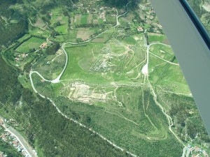
This low-resolution, oblique aerial photography captured over the archaeological site of Saqsaywaman near Cusco, Peru in early 2006 is a nice example of what can be done with non-traditional aerial images. These four images were taken with a 1.2 megapixel camera from a relatively low altitude and represent the type of data you would typically expect when collecting close-range digital images via a low flying aircraft, UAV, kite, or balloon.
Download these images here and follow the workflows for photogrammetric processing in PhotoScan or PhotoScan Pro.
Mapview of the dataset
View this in a larger map
Please note. This data is distributed under a Creative Commons 3.0 License (see http://creativecommons.org/licenses/by-nc/3.0/ for the full license). You are free to share and remix these data under the condition that you include attribution as provided here. You may not use the data or products in a commercial purpose without additional approvals. Please attach the following credit to all data and products developed there from:
Credit: Center for Advanced Spatial Technologies (University of Arkansas) and Cotsen Institute for Archaeology (UCLA)
Longer version: Data acquired under the authority of the Alexei Vranich, Cotsen Institute for Archaeology (UCLA). Data distributed by the Center for Advanced Spatial Technologies (University of Arkansas).
