[wptabs mode=”vertical”] [wptabtitle] ALS and Archaeology.[/wptabtitle] [wptabcontent]
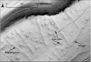
Hillshaded lidar terrain model revealing (undated) remains of field systems now located within the Chailluz Forest, France. ALS Data credit: Region de Franche-Comté / MSHE Ledoux
[wptabtitle] Basic Processing and Classification. [/wptabtitle] [wptabcontent] Archaeological applications demand high quality processing and classification of the ALS data. Because many buried or surface archaeological features are both small scale (in xy) and low relief (in elevation) and are often in woodlands or other heavily vegetated areas, good alignment within the point cloud is necessary to minimize noise, and a good classification is necessary to distinguish between low vegetation and low relief terrain features which may represent archaeological remains.[/wptabcontent]
[wptabtitle]Visualization.[/wptabtitle] [wptabcontent]Processing and visualization clearly affect interpretations. There are many possibilities to generate new models and visualizations, and a concurrent possibility of continually tweaking parameters in the hope of ‘improving’ the model. Archaeologists undertaking a project using visualizations should pose two questions. First, how much information can be retrieved, and with how much effort? Crutchley (Cowley and Opitz 2013) observes that if one model gives 90% of the nominal ‘total’ information, then the decision not to chase the other 10% may be a practical one. This pragmatic approach avoids the dangers of loosing sight of survey objectives in an endless round of data processing and manipulation. However, assessing the cost/benefit and deciding where to stop data manipulation, because a certain approach gives enough information for the task at hand, is not always obvious.
Popular 2D visualizations of bare earth DTMs in archaeology include:
- -Classic Hillshades
- -Multi-Directional Hillshades
- -Slope Maps
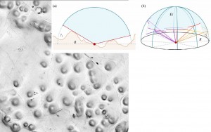
- -Sky View Factor
- -PCA of multiple Hillshades
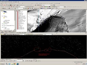
Simultaneous viewing of the point cloud, in profile or as a 3D model, alongside the shaded terrain model is common practice. The combined information from multiple views of the same data helps interpreters to understand if a small bump is likely to be a potentially archaeological mound, or built up soil around the base of a particularly large tree, not fully removed by the filtering process.
[/wptabcontent]
[wptabtitle] Metadata about Visualizations. [/wptabtitle] [wptabcontent]Providing detailed information on how a model and visualization was created is essential for others to understand and evaluate the end product and interpretation. Kokalj et al. (in Cowley and Opitz, 2013) recommend metadata about processing and visualizations as follows:
- -data scanning: scanner type, scanning density, density of a combined dataset, scanning date;
- -data processing: method(s) used, parameter settings, description of the processing goal (e.g. producing a terrain model, removing just the vegetation), elevation model resolution;
- -visualization: method(s) used, parameter settings (e.g. hillshading (Sun elevation and azimuth), LRM (method, distance), SVF (distance, directions);
- -interpretation process: reliability of the results (qualitative if quantitative evaluation is not possible, e.g. low to high, description of each class is recommended).
[/wptabcontent]
[wptabtitle] Analyses Using lidar DTMs. [/wptabtitle] [wptabcontent]The detailed terrain models produced from ALS data are used in archaeological research and cultural resource management as inputs for a number of analyses. These include:
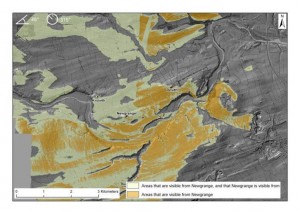
- -Visibility Studies
- -Predictive Modeling
- -Least Cost Path and Cost Surface Modeling
- -Erosion Assessments
[/wptabcontent]
[wptabtitle] External Resources.[/wptabtitle] [wptabcontent]

The ArchaeoLandscapes Project is an EU based project promoting the use of remote sensing and surveying technologies in archaeology. Their website is an excellent resource for both general information and case studies about the use of ALS in archaeology.

The English Heritage Guide to Airborne Laser Scanning provides good information on the use of ALS in the context of a national cultural heritage management organization.[/wptabcontent] [/wptabs]
